Laboratories (Educational/Research)
Educational
kerpelis@uniwa.gr
Office Address
Αncient Οlive-grove Campus (Campus-2)
UNIVERSITY OF WEST ATTICA
SCHOOL OF ENGINEERING – DEPARTMENT OF CIVIL ENGINEERING
Educational Laboratory of “Geodesy and Surveying Engineering Applications”
Responsible: Ploutarchos KERPELIS, Lecturer
E-mail: kerpelis@uniwa.gr
1. Location
The Educational Laboratory of “Geodesy and Surveying Engineering Applications” belongs to the Department of Civil Engineering of the University of West Attica. The Laboratory is located on the Ground floor of the C Building (CA011) at the ANCIENT OLIVE GROVE Campus (250 Thivon & P. Ralli str, Egaleo Postal code 12241, Athens +302105381719)
2. Main objectives of the Laboratory
The Laboratory of “Geodesy – Surveying Engineering Applications” serves the teaching needs of the course “Geodesy” (of the 3rd Semester) and the course of “Surveying Engineering Applications” (of the 4th Semester).
a)About Geodesy:
In the Laboratory, the graduate students acquire fundamental knowledge of Geodesy and Topography, and comprehension skills of these. They acquire a general overview of the wider field of the Surveying Engineering. Also, they become familiar with the basic field topographic procedures and develop skills in measurements using a measurement tape, surveying level and a total station. They combine knowledge to resolve fundamental topographic problems: coordinate calculation, coordinate conversions (polar, cartesian), coordinate transformations, calculations of geometric quantities (distances, areas). In the next courses of their studies (Geodetic Applications), the knowledge is combined with the practices they have acquired. They link theory with practice through participation in individual and group exercise, while they become familiar with the organization and presentation of geodetic measurements.
b)About Surveying Engineering Applications
In the Laboratory, the graduate students use their knowledge from the previous course (Geodesy) and utilize it in the procedures of measurements and calculations. They understand the procedures of a topographic survey from the identification of the study area to the final production of a topographic drawing as well as the procedures of a stakeout. They get familiar with the methodologies of measurements, solutions and rendering of elements of the field and their representation, as well as the methodologies of taking information from diagrams and transferring them to the field (stakeouts). Also, they analyze the elements of the field to be measured, calculate elements that will lead to its accurate representation and combine – synthesize the information obtained from the measurements in the field for the evaluation of their final product. Collaboration is achieved with fellow students in the group work of surveying and students stake out in the laboratory part of the course. They develop to a higher degree the skills in basic concepts/knowledge of the use of geodetic instruments, while they connect theory with practice through participation in individual and group exercise. Also, they become familiar with new technologies of measurement and data collection.
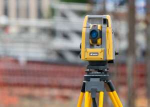
3. Laboratory equipment
The Laboratory equipment includes: modern geodetic stations and digital surveyors along with their accessories (shoulder tripods, heavy-duty aluminum tripods, stadia, javelins, etc.), digital rangefinders, electronic rangefinders, compasses, styluses, GPS, reflecting telescopes, prisms and measuring tapes. Much of the equipment is available in various types and models. The Laboratory is also in the process of enriching its equipment, following orders for new items.
4. Education
Academic staff teaches the Laboratory of “Geodesy – Surveying Engineering Applications” in parallel with the teaching of the theory of these issues, as courses in the Department of Civil Engineering at University of West Attica. In this way, theoretical knowledge is supplemented by training in laboratory exercises related to Geodesy and Surveying Engineering Applications aspects. The Laboratory supports the experimental and computational work needed for undergraduate dissertations.
5. Dissemination of Research Activities and Financial Management
The results of the research activities are disseminated in the form of Diploma theses, project reports and scientific papers published in scientific journals or proceedings of conferences.